Finding the right GPS for commercial trucking can streamline routes, reduce downtime, and improve overall efficiency. The following selections focus on truck-specific routing, bridge height alerts, dock access, and satellite imagery to help drivers plan safer, faster trips. This guide highlights five standout models with strong road-ready features and reliable update cycles for long-haul and regional fleets.
Summary of chosen products:
- Garmin dezl OTR720 – 7″ touchscreen, custom truck routing, BirdsEye satellite imagery, dock and parking alerts
- Garmin dezl OTR620 – 6″ touchscreen, truck routing, Birdseye imagery, dock access
- Garmin dezl OTR610 – 6″ display, custom routing, high-resolution satellite imagery
- Garmin dēzl OTR1010 – 10″ display, large-screen navigation, advanced arrival planning, satellite views
- Rand McNally RANDTAB7 – 7″ screen, Rand Navigation 2.0, extensive trucking POIs and alerts
Garmin dezl OTR720: 7-Inch Truck Navigator
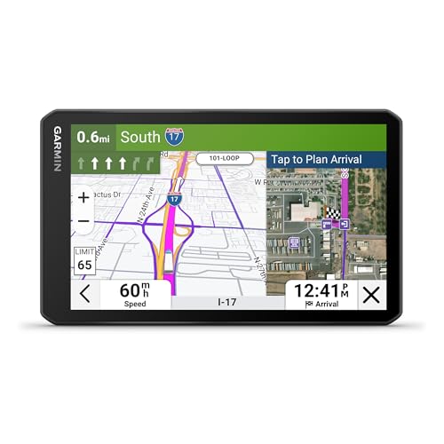
The dezl OTR720 features a bright 7-inch touchscreen designed for in-cab visibility. Its custom truck routing accounts for truck size and weight where available, with alerts for bridge heights and sharp curves to help drivers avoid hazards. The device supports approach and planning for loading docks and security gates, aiding route selection in complex settings. BirdsEye Direct Satellite Imagery provides high-resolution views of destinations, helping drivers verify approach options before arrival.
Key considerations: screen clarity aids multitasking in the cab; route customization improves efficiency; satellite imagery supports pre-trip assessment. Limitations include coverage caveats where vehicle specifics may not be reflected in every area, and the need to defer to posted signs and conditions in real time.
Garmin dezl OTR620: 6-Inch Truck Navigator

The dezl OTR620 provides a compact 6-inch display with truck-focused routing. It supports routing based on the vehicle’s size and weight, with alerts for upcoming bridge heights and sharp curves. Dock and gate access is streamlined by guiding drivers to loading dock entrances. BirdsEye Direct Satellite Imagery delivers overhead views of destinations for better pre-arrival planning. It is important to verify current signs and road conditions, as truck routing isn’t guaranteed in all areas.
Supporting factors include its balance of size, clarity, and truck-specific features. Potential drawbacks involve area-dependent routing details and the need to cross-check with roadway signs during complex moves.
Garmin dezl OTR610: 6-Inch Truck Navigator

The OTR610 offers a bright, high-resolution 6-inch display with custom routing tailored to truck dimensions. Alerts cover upcoming bridge heights, weight limits, sharp curves, and steep grades. The device integrates BirdsEye Satellite Imagery for high-resolution aerial views of loading docks and security gates, aiding precise arrival planning. As with other models, routing is not guaranteed in all areas and drivers should always defer to posted signs and road conditions.
Strengths include an accessible screen size and robust alert system. The main caveat is the potential for incomplete vehicle-specific routing in some regions, necessitating cross-checks with real-time signage.
Garmin dēzl OTR1010: 10-Inch GPS Truck Navigator
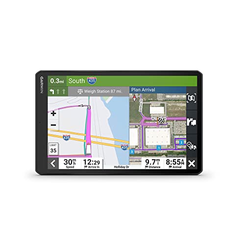
The dēzl OTR1010 delivers a large 10-inch touchscreen with crisp, high-resolution visuals for easy in-cab operation. It provides custom trucking routing based on vehicle size and weight, along with alerts for bridge heights, weight limits, sharp curves, and steep grades. BirdsEye Satellite Imagery offers high-resolution aerial views of loading docks and truck entrances, supporting informed decision-making before arrival. The expansive display supports both landscape and portrait views to suit driver preferences.
Considerations include the benefit of a larger interface for multitasking and detailed view of routes, but larger devices can be heavier to mount and may require more space in the cab. Always consult posted signs for any local restrictions or changes in road conditions.
Rand McNally RANDTAB7: 7-Inch Truck Navigator

The RANDTAB7 uses Rand Navigation 2.0 with 2025 maps and tailored trucking routes. It supports route customization by truck dimensions and factors real-time traffic, weather, fuel price, and speed camera alerts. Built-in warnings and POIs include weigh stations, curves, hills, parking, truck services, and restaurants, aiding decision-making along long hauls and tight urban runs. The platform emphasizes practical routing for fleets and independent operators alike.
Strengths include a broad set of trucking-specific POIs and up-to-date maps. Potential limitations involve reliance on Rand Road IQ routing and the need to confirm path validity in dynamic environments with changing road conditions.
Buying Guide: Key Purchase Considerations For Trucking GPS
When selecting a GPS for commercial trucking, several factors determine long-term value and reliability. Consider screen size and readability in varying cabin lighting, with larger displays offering simplified multitasking but potentially more mounting space. Routing features should account for vehicle dimensions, weight, and axle count, and signal when detours align with regulatory restrictions or low-clearance routes.
Satellite imagery and real-time map updates are valuable for plan-ahead decisions, dock access, and yard layouts. Assess whether your operation requires Birdseye or equivalent aerial views for critical destinations, and ensure the device supports loading dock entrances, gate access, and parking information along routes.
POI coverage matters for weigh stations, rest areas, fueling, repairs, and freight-specific services. Evaluate whether PrePass and other skip- weigh transport features are integrated, as these can save time at checkpoints. Lastly, check map update frequency, regional coverage, and compatibility with your preferred mounting options and in-cab workflows to minimize distractions while driving.
Comparative notes:
- 7″ or 10″ screens offer different balances of visibility and cab space; choose based on your truck’s cockpit layout.
- Custom routing based on truck size is essential; verify that the regions you operate in have accurate vehicle profiles and that road signs remain a primary reference.
- BirdsEye Satellite Imagery enhances destination awareness but should be used with caution and cross-checked against current site access conditions.
- Dock and parking data reduces deadheading time; ensure the device lists loading docks and nearby parking facilities along planned routes.